Telemetry and Remote Sensing Applications
Module ID
Ε808
Semester
8
Hours/Week - ECTS
4 – 5


Learning Outcomes
Upon successful completion of the course, the student will be able to:
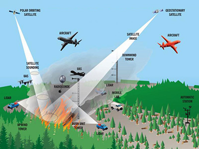
- Understand and describe the mechanism of remote sensing and aerial photography.
- Recognize the electromagnetic spectrum and applications of its use.
- Recognize satellite sensors and types of satellites.
- Explain the techniques of radiometric image enhancement and its spatial enhancement (filters).
- Define and resolve image transformation problems.
- List Radar and microwave imaging mechanisms.
- List supervised and unsupervised classifications and classification accuracy.
- Describe the mechanisms of the interaction of radiation with the Earth’s environment.
- Synthesize his knowledge to propose solutions to problems concerning remote sensing applications in the Terrestrial and Marine environment, Physical
disasters etc.
Indicative Module Content
- Introduction to Remote Sensing and Aerial Photography
- Electromagnetic radiation
- Interaction of radiation with the terrestrial environment
- Satellite Sensors and Satellite Types
- Thermal Imaging
- Radar and Microwave Imaging
- Coordinate Systems & Geometric Correction of Satellite Images
- Radiometric Image Enhancement
- Spatial Image Enhancement (filters)
- Image Transformations
- Supervised and Unsupervised Classifications and Classification Accuracy
- Remote Sensing Applications
- Remote Sensing Applications in Land and Marine Environment, Natural Disasters, etc.
